Stay Informed on GEO-ESCON's Ongoing Projects and Initiatives!
These projects exemplify the diverse range of activities and expertise within GEO-ESCON and their summaries provide valuable insights into the type of research and initiatives NGA has committed to funding.
PI: Ezra Che, Oregon State University
CO-PIs: Michael Olsen, Oregon State University and Chase Simpson, Oregon State University
Summary: Thanks to the rapid evolvement of 3D sensing technologies, a wide variety of systems are accessible for “reality capture” with tremendous quality and efficiency. It is crucial to clearly report the uncertainty of various data products and subsequent models considering their use cases, which can be challenging for the conventional accuracy assessment and reporting approaches. To overcome this challenge, this project aims to develop a novel, data-driven, scale-variant QA/QC method to estimate, report, and visualize the uncertainty of the data acquired from multiple sources to guide the data fusion process and support 3D modeling and other applications.
PI: Demián Gómez, The Ohio State University
CO-PI: Michael Bevis, The Ohio State University
Summary: The main goal of this project is to develop and produce a trajectory parameter prediction model (TPPMs) that can be used to generate dynamic trajectory models in South America (SA). These TPPMs will be created using most of the geodetic GNSS stations and DInSAR data in the region of interest. The target uncertainty of the TPPMs is 1-2 cm in the horizontal and of 3-5 cm (or better) in the vertical. We selected SA as the demonstration region for our approach since large amplitude and non-steady deformation is common in this continent.
PI: Kevin Mickus, Missouri State University
Summary: Ground gravity and magnetic data will be collected by Missouri State University and the Iraq Geological Survey at intervals between ¼ and ½ kilometers along all roads in northeastern Iraq. The horizontal location and elevation of each station will be determined using differential Global Positioning System methods. The gravity data will be processed into Complete Bouguer gravity anomalies and the magnetic data will be processed into residual magnetic anomalies in order for the data to be used to determine the crustal structure in northeastern Iraq.
PI: Seth Warn, University of Arkansas
CO-PIs: Jackson Cothren, University of Arkansas and Hank Theiss, University of Arkansas
Summary: Images taken by "KeyHole" reconnaissance satellites from 1960 to 1984 are now available to the public, and are the best imagery available for many locations during that period. However, as currently provided, these images are incompatible with modern geospatial workflows. The OpenKeyhole project is developing tools that bridge the gap, allowing users to fully take advantage of keyhole imagery.
PI: Michael Olsen, Oregon State University
CO-PIs: Ezra Che, Oregon State University, Jaehoon Jung, Oregon State University, and Chase Simpson, Oregon State University
Summary: Tools to perform coordinate system transformations have different levels of complexity and accuracy. Some are focused at producing mapping grade products while others are more rigorous for geodetic applications. Users are often confused and do not understand potential limitations of these tools. As a result, errors and inconsistencies become difficult to detect, particularly when processing the data volumes associated with point clouds. This project explores the reliability of point cloud coordinate and reference frame transformations and develops robust techniques to perform and evaluate these transformations. The project will produce a “Point Cloud Transformation Toolkit (PoCToK)” capable of geodetic grade transformations.
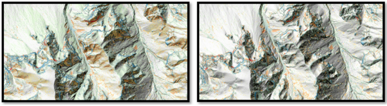
Example change analysis for airborne lidar datasets acquired 9 years apart in the Columbia River Gorge with horizontal offsets due to improper datum realization (left) and corrected data (right). Green/Blue values indicate positive change and orange/red values indicate negative change.
PI: Alper Yilmaz, The Ohio State University
CO-PI: Charles Toth, The Ohio State University
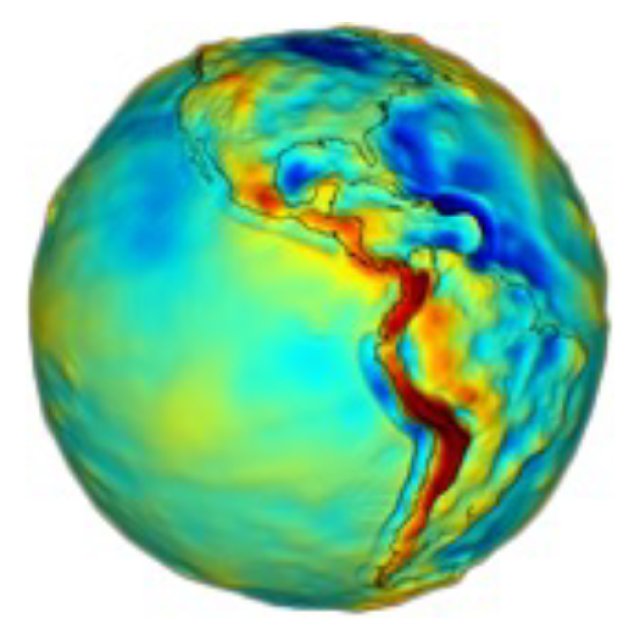
Summary: Precise gravitational measurements are necessary to create a model of the Earth's gravity field. This model helps establish the connection between the reference ellipsoid and the geoid, which is crucial for GPS positioning. Having a better understanding of the gravity field's details allows for a more accurate conversion of WGS84 GPS positions into a standardized coordinate system.
Measuring gravitational fields requires specialized and costly equipment, and deploying gravimeters becomes especially complex when dealing with vast areas. The current methods face two primary challenges. Firstly, the instruments themselves used for gravity measurement are quite large. Secondly, there are limitations in both the coverage area and the level of detail in the spatial measurements of gravity. To address these challenges, our project suggests an innovative crowd-sourcing solution. We utilize MEMS IMU sensors found in smartphones to measure the specific force and subsequently calculate gravity. This approach aims to overcome the size and coverage limitations associated with traditional methods.
PI: Jinha Jung, Purdue University
Summary: This project addresses the geomatics challenge of constructing a real-world representation of the globe by establishing a foundational Digital Twin. We propose developing an integrated web-based geospatial database for a nation-scale Digital Twin. A reliable state-wide 3D topographic map and large-scale 3D urban maps of major US metropolitan areas will form the initial foundation. The web-based database will be designed to allow people to easily access, develop, and update geospatial data in an open, collaborative manner. Furthermore, we will demonstrate the utility of our Digital Twin in various applications, primarily focusing on enhancing citizens' livability and promoting the nation's safety.
PI: Jackson Cothren, University of Arkansas
Summary: The notion of a digital twin, a digital replica of a thing or system used to test hypotheses and understand characteristics and behaviors under different conditions, has its origins in product lifecycle management. More recently, the digital twin concept has evolved beyond the product to include complex physical systems, including both the natural and built environment. In this project we treat the digital twin as a dynamic surface model - one that is being updated constantly as new source data (images, LiDAR, etc.) are available – and attempt to better understand when this new information represents a change to the physical surface or when it is a better (or worse) representation of the existing surface. Source error models and rigorous error propagation guide the approach which will be visualized using a digital twin testbed over Northwest Arkansas that can accommodate both 3D Tile and generic point cloud formats.
PI: Jamin Greenbaum, University of California San Diego
CO-PI: Yuepeng Li, Florida International University
Summary: A team of researchers from the Scripps Institution of Oceanography and Florida International University will use airborne and orbital remote sensing data to investigate and develop improved approaches for defining the Earth’s surface height and gravity field. The project will utilize existing data to develop new analysis software and a long endurance uncrewed aerial vehicle to demonstrate recovery of high-resolution gravity data for improved geoid estimation. The project will explore the potential for integrating multiple data sources to create consistent height models; all activities are motivated by the urgent need to develop and improve a unified global height system.
PI: Lori Magruder, University of Texas at Austin
CO-PIs: Srinivas Bettadpur, University of Texas at Austin and R. Steve Nerem, University of Colorado Boulder
Summary: This effort will study a modernized geomatics infrastructure to integrate lunar and terrestrial geodesy as a means for mobility beyond low Earth orbit. The research will push forward the knowledge required for the next generation positioning, navigation and timing (PNT) capabilities and pursue hypothesized scenarios of space geodesy, geodetic measurements and critical observation for comprehensive cislunar operational applications.
PI: Vasit Sagan, Saint Louis University
CO-PIs: Jackson Cothren, University of Arkansas and Jeremy Maurer, Missouri University of Science and Technology
Summary: Overall objective of the proposed work is to develop an absolute accuracy model for InSAR, in order to characterize the accuracy of global InSAR deformation models. In particular, (1) we will investigate how uncertainty changes over spatial and temporal scales with specific applications in levee monitoring, landslide prediction, and risks to man-made infrastructure, and (2) determine how accuracy is deteriorated proportionally to the distance from ground control points established along Missouri and Arkansas gradient.
PR# NGA-U-2024-00641